It is disappointing to see that Mike Harris has ceased the production of his printed bus maps. These maps provide comprehensive coverage of the Greater London bus network, including commercial routes that cross the Greater London boundary.
Here is the statement from his website:
IMPORTANT ANNOUNCEMENT
After 30 years of producing The Greater London Bus Map, I have decided to cease production of printed bus maps. The difficulty in obtaining accurate and up-to-date information in advance of publication, not least from TfL, coupled with my advancing years and the stress of production has meant I must call time on something that I have enjoyed creating and maintaining.
I feel Transport for London should once again promote its bus network, a role that in my opinion it has side-stepped for far too long. I will, however, continue to produce the digital download version of my maps, and will endeavour to update them more frequently. Please subscribe to my occasional newsletter if you wish to be notified when updated digital maps become available.
I am grateful to all those customers who have purchased and supported the map over the years and enabled me to raise more than £30,000 for various charities.
I agree with his point that Transport for London (TfL) should do more to promote the bus network, particularly as usage has declined over the last decade.
Analysis of #Transport for #London #data reveals a decade of decline for the busiest bus routes. Route 18 remains top with 12.1m passengers in 2024/25, despite a 31% drop since 2014/15. Route 25 saw the largest fall (-59%) due to restructuring, while Route 38 usage declined by 35%.
— CLondoner92 (@clondoner92.bsky.social) December 20, 2025 at 1:15 PM
[image or embed]
The final issue of TfL’s own printed quadrant bus maps was in March 2016. These remain available to download via the Freedom of Information section of their website.
The Mayor of London, Sadiq Khan, previously provided the following justification for why TfL ceased production:
Reference: 2017/4560
Date: Friday 1 December 2017
With four sector bus maps, updated twice a year, the cost to provide the map online would be £160,000. Bus services change more frequently than other services and the maps very quickly go out of date.
Bus journeys, including those using multiple routes, can be planned on TfL Journey planner. Customers can also view or print a street map to aid onwards journeys.
While I understand that maps can quickly become outdated—especially as TfL is legally required to consult on proposed service changes—their importance remains high. Currently, London TravelWatch directs users to Mike Harris' website for the London Bus Map and notes that the London Transport Museum sells them; this is a great option if you want to buy them from the store in person without having to wait for delivery. The London Bus Museum (which is independent of TfL and the LTM) also stocks these maps.
TfL does still provide a "Key bus routes in Central London" map alongside local "spider" maps on their website.
The Digital Divide and Accessibility
TfL’s 2022 Bus Action Plan highlights the importance of providing information:
The bus network is complex. It is accessed from more than 19,000 bus stops, almost all of which are unstaffed. It shares street space with cars, which makes journey times more variable. Sometimes it can be difficult to know which bus to use, exactly when the bus will arrive or whether there will be space to get on, especially when there’s disruption. These issues are often even more pronounced for disabled customers who must be assured that their pre-planned routes offer the accessible and inclusive infrastructure and services they require for their end-to-end journeys.
People have grown accustomed to highly accurate and easily accessible real-time information in all areas of their lives, including travel by other modes, shopping and media. This raises their expectation for a level of information to be available when using the bus network which is often not met at the moment, making bus journeys feel slower and less reliable.
Providing more and better-quality information can encourage more bus travel. It gives a sense of control and confidence, directly addressing the anxiety and frustration which uncertainty and disruption creates. Having this sense of control is key to people’s choice of transport mode, particularly for people who normally drive. The potential is significant, with three out of five non- bus-users saying they would take the bus more if real-time information was easier to access.
The changing digital landscape also means that information products that were once thought of as ‘extra’ features could soon become critical factors in driving journey decisions. The risk of inaction is real: failure to match evolving customer expectations can lead to terminal decline. We need to keep pace by providing customers with accurate information across a range of static and real-time digital channels to enable customers to plan their journeys and support them when things don’t go according to plan. As part of this we will continue to engage with established third party platforms and developers, championing how our open bus data can improve the customer experience.
At the same time, we must continue to renew and maintain our systems that enable us to provide our customers with information. iBus, our automatic vehicle location system, is at the heart of this. As well as being the primary data source for live journey times, the system also enables other forms of data provision.
Action 1
Promote our bus services and provide the information our customers need to be in control of their journeys by:
• Running wide-ranging campaigns to raise awareness of the bus network as a relevant and appealing sustainable alternative to the car and the role it can play in the future of the city, building on our current campaigns around recovery and zero-emission buses
• Promoting our services, new routes and pilot schemes, fares that give value for money and our TfL Go app, which provides real-time travel information
In addition, the 2018 Mayor’s Transport Strategy emphasised the necessity of inclusive design:
Disabled people, who currently make up 14 per cent of London’s population, on average make one third fewer trips than non-disabled Londoners and, as the city’s population ages, an increasing number of Londoners could face barriers to travel. Inclusive design must be used across the transport system to ensure it is accessible to all. TfL and its partners must continue to make walking and cycling environments accessible to older and disabled people, and provide lifts, level access and better customer care and information at stops and stations so people do not have to resort to private transport. The Mayor aims to improve the overall accessibility of the transport system including, by 2041, halving the average additional time taken to make a public transport journey on the step-free network compared to the full network.
Enhancing customer service In London, almost every resident, worker and visitor is a customer on the city’s transport system. The experience of travelling around London has improved significantly in recent years. However, there are still too many inconsistencies across the network in terms of quality and reliability, information provision and general integration between different transport options. This can cause stress for individuals and, more broadly, weaken Londoners’ confidence in the public transport system. An improved quality of service is needed to enable more Londoners to positively choose to use public transport as an alternative to the car.
Policy 13
The Mayor, through TfL and the boroughs, and working with stakeholders, will seek to make the public transport network easier and more pleasant to use, enabling customers to enjoy comfortable, confident, safe and secure, informed and stress-free travel.
Getting the basics right
Across all modes, what customers value the most is the service provider ‘getting the basics right’. This means providing a reliable public transport service that gets customers to their destination safely and on time. Customers should have access to accurate real-time information and assistance along the way. There should be easy and accessible interchange between different public transport services and with walking and cycling.
This means, for the rail and Underground network, more frequent and reliable trains; fairer, simpler fares (including extending Oyster and contactless payment to more stations around the edge of London); modern, staffed stations; and information at every stage of the journey. On the bus network, there will be improved customer information during disruption and delays, as well as enhanced on-board services (e.g. cleanliness, seating and air conditioning). New customer service standards will be developed for bus stations, and customer-focused training – with a continuing emphasis on equality issues, particularly for older and disabled people – will be delivered to all bus drivers and front-line staff.
With 27 million journeys taking place in London every day, inevitably sometimes things will go wrong, so it is important that TfL and other transport service providers support customers when this happens. When there is service disruption, customers need to be given up-to-date information that enables them to make alternative travel arrangements. Customers should be confident that staff are helpful, knowledgeable and empowered to assist whenever they need help.
Making bus services more accessible and inclusive
Buses are typically the most common form of public transport used by older people, disabled people and those travelling with children, often with prams or buggies. Buses are a relatively accessible form of public transport – all London buses meet strict accessibility requirements, and 95 per cent of bus stops are now wheelchair accessible. Specific training on helping those users with accessibility needs is being delivered to bus drivers, and TfL works with bus operators to ensure this training is put into practice in daily service provision. Nevertheless, on-board crowding, competition for the designated wheelchair space and the internal layout of the vehicle can negatively impact the experience of using buses. There is therefore a real need to further improve bus accessibility through future bus design.
In addition to making more bus stops wheelchair accessible, at key locations such as interchanges, a higher level of improvements will include improving shelters, seating, interchange information, and locating stops as close as possible to key destinations with excellent walking links.
While TfL's focus on digital tools and the TfL Go app is a positive step, it overlooks the concerns regarding those who are digitally excluded, a point specifically raised by London TravelWatch. I have volunteered to highlight issues such as overseas visitors being unable to access the internet due to high roaming fees. Furthermore—and while unrelated to bus maps, it is still worth noting—there remains a vital necessity for paper tickets, such as the Travelcard (which was thankfully retained), for those who have lost their smartphones or cards to theft and must wait for replacements.
Furthermore, bus maps are not just for tourists. They are essential for transport enthusiasts who use them as souvenirs and to document the ongoing history of the network. These enthusiasts often act as promoters of public transport.
Bus Maps Elsewhere
Many other regions across England continue to provide comprehensive bus network maps:
● Cornwall: https://www.transportforcornwall.co.uk/bus-network-map
● Greater Manchester: https://tfgm.com/maps
● Merseyside: https://www.merseytravel.gov.uk/customer-information/routes-and-maps/
● South Yorkshire: https://www.travelsouthyorkshire.com/en-gb/journeyplanning/public-transport-maps
● West Midlands: https://www.tfwm.org.uk/plan-your-journey/discover-the-west-midlands/local-area-maps/
● West Yorkshire: https://www.wymetro.com/buses/bus-maps-and-guides/
The Bus Atlas website covers many more maps for Great Britain, though it refers users back to Mike Harris for London-specific coverage.
Major global cities such as New York, Paris, Amsterdam, Tokyo, and Rome also continue to provide detailed maps of their bus services.
● NYC: https://www.mta.info/maps
● Paris: https://www.ratp.fr/en/plan-bus
● Amsterdam: https://www.gvb.nl/en/gvb-maps
● Tokyo: https://www.kotsu.metro.tokyo.jp/eng/maps/bus/
● Rome: https://www.atac.roma.it/en/utility/maps
Looking Ahead
TfL provides open data feeds and API documents for third-party developers, which power apps and websites like Citymapper and Bus Times.
Users can also access the bus routes map via TfL’s GIS Open Data Hub, which includes certain railway replacement services running parallel to the Underground and Elizabeth line.
For those still seeking a printed alternative, Quickmap provides its own updated (unofficial) London Bus Map and offers printed versions on its website.
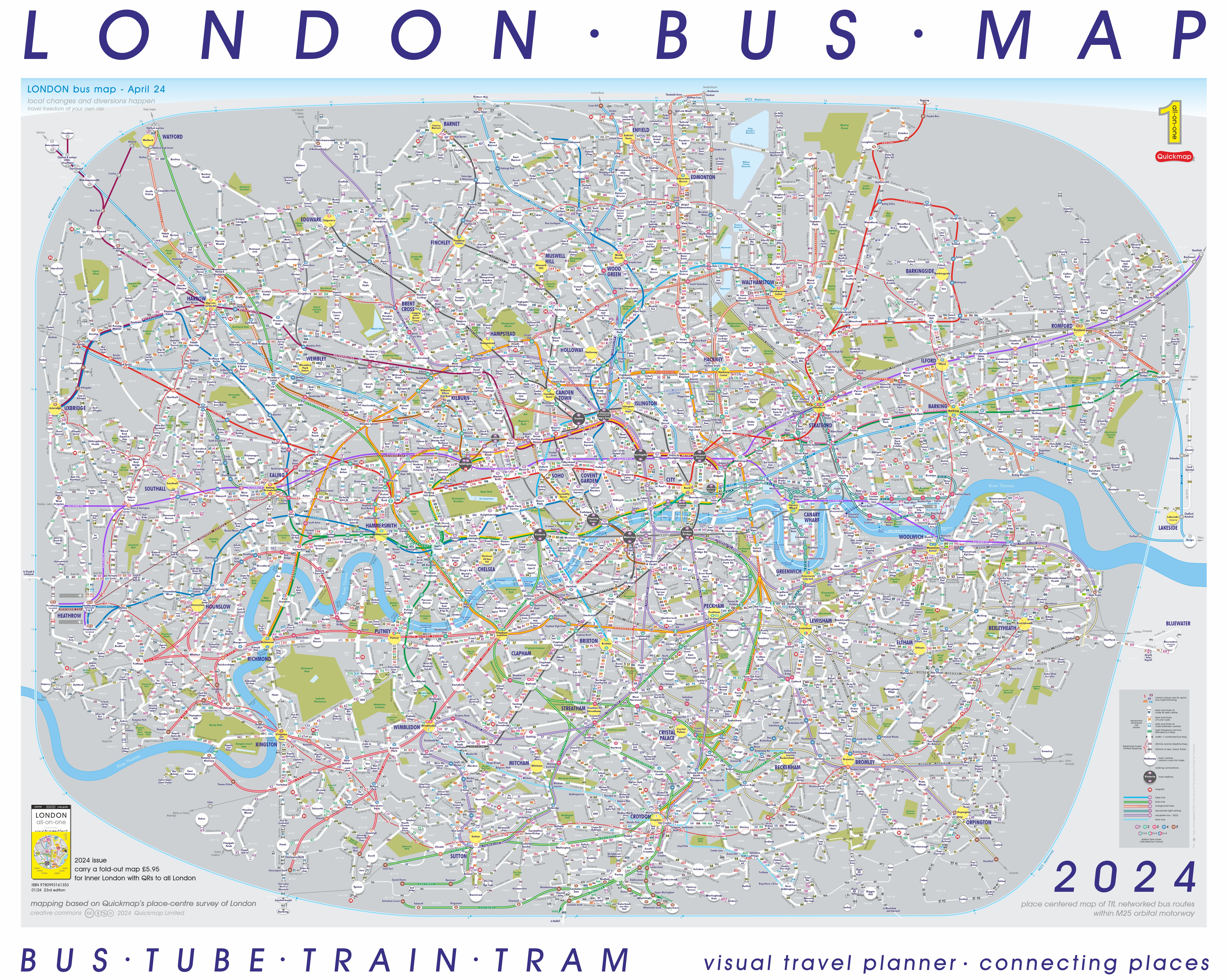
London Bus Map by Quickmap. Licensed under Creative Commons.
It is vital that we continue to support his work, and ideally, we may yet see his maps return to print in the future. I believe TfL should be working together with him to ensure the public has the best possible access to bus information.
Lastly, you can contact your local elected representative, such as a London Assembly member, a councillor, or your local Member of Parliament (MP), using the Write To Them website, or find your local MP on the UK Parliament website. Assembly members are particularly relevant here as they are tasked with holding the Mayor and TfL to account on transport issues.
I would like to extend an invite for you to follow me on X (formerly Twitter) for transport-related updates. You can find me by searching for @CLondoner92 or by clicking on the direct link to my X page here. I am also present on BlueSky and Mastodon. I look forward to connecting with you on these platforms. Thank you for your support.